Astrogeographical positions of the largest cities in 100 CE. The astrology of urban culture and development of urban centers
Related articles: Astrogeographic positions of the largest cities in 1500, Astrogeographical positions of the largest cities worldwide, The oldest urban centers in history,
Astrogeographical positions of the largest cities in 100 CE
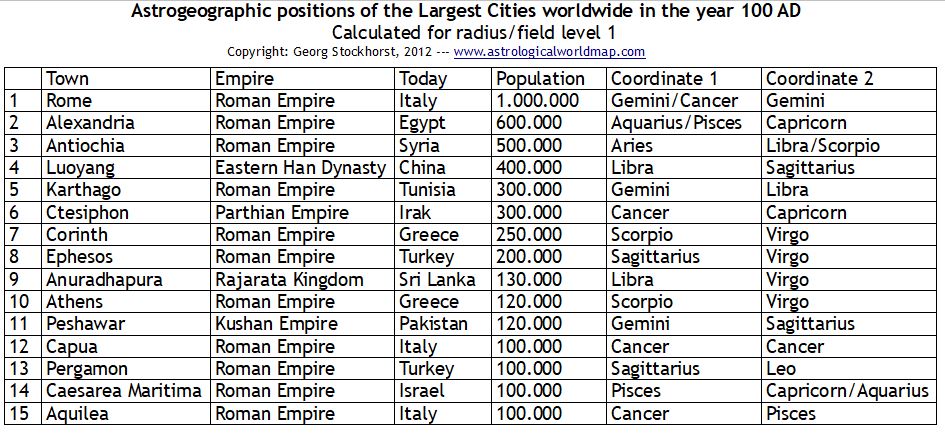
The table of the largest cities worldwide in 100 CE and their astrogeographic positions is calculated for morphogenetic radius/field level 1 which describes the supraregional significance of the cities.
Why look at the historical list of cities?
Some of the places on the list like Rome, Alexandria or Athens still continue to be extremely large and important cities even after 2000 years. These places have gained the status of archetypes of continuously important cities. Others like the roman harbor Caesarea Maritima have lost their importance or as in the case of the glorious Carthage have even ceased to exist. History is what relates places to the 4th dimension : time, which is the most important field of astrology. Therefore: the older a city is the more data about the evolution of the place in relation to the astrological transits of the outer planets can be observed for evaluation.
Astrological observations on urban culture
Almost every single one of the places on the list was an extremely important capital city of the country or region where it lies at the time. Capital cities are direct or indirect indicators for the culture and/or the country or state which they stand for. This is why the list also offers a chance to take a deeper look at the corresponding signs of the countries that the places stood for. And as we are dealing with the early times of the history of urban mega centers we can take a closer look at the basis which led to the development of city culture in the different places.
For example: not one of the cities from the list above lies in earth sign Taurus the sign of rural market places, town centers, food production, agriculture, wealth and possession of land. Taurus appears not to have been a locational factor that supported the development of really large cities in the 1st century AD. That can be concluded from the list above. But that does not mean that Taurus would not be an indicator for a successful major city in later periods of history. Moscow the capital of the largest country that ever existed on the planet is an example for a megacity located in Taurus. A possible explanation could be that Taurus had too much focus on agriculture and wasn`t useful for the development of urban agglomerations in the early history of megacities.
Earth sign Virgo the sign of health care, optimal use of resources and strategic planning and Cancer the sign of springs and wells, fertility, motherhood and feeling at home seem to have been more supportive for the development of large cities. These 2 are the most frequent signs on the list with 4 and 5 entries. Cancer even has one entry more in the list than Virgo which makes it the mother-sign of urbanization or urban culture of the largest cities. Water sign Pisces (3) appears as the indicator for connecting with the sea. Capricorn (3) as the sign of government administration. Libra (3) as an indicator for the ideal of higher cultural and aesthetical standards. Gemini (3) as the sign of strategical importance and technology. Highly defensive Scorpio (3) as the indicator for the fortress character and the development of trade guilds and caste systems. And Sagittarius as the sign of thinking, knowledge and priest castes as the indicator for further development of scientific institutions, research and culture in general.
Aquarius (2 entries) as the sign of living under the open sky and being outside of town centers only occurred as a coordinate in combination with its neighbor signs Capricorn or Pisces, probably marking the suburbs, the slums where the poorer people lived, industrial areas or zones for recreation and not the town center itself. But on the other hand Aquarius must have had a stimulative influence on innovation, inventions, self-organization of the population and social changes. The two cities on the list in Aquarius Alexandria and Caesarea Maritima are particular examples of cities which didn´t develop “naturally” over long periods of time but were artificially created in a short period of time.
The 2 fire signs Aries (warfare) and the royal sign Leo (royal centers) have only one entry in the list of antique mega-cities. In the case of Aries the sign of warfare the reason why larger cities didn`t develop frequently may be that such areas stand for a situation where the region was subject to frequent attacks from all sides, So that the cities were more frequently plundered and destroyed than in other regions.
The region of Athens is an example for an important urban center with both resonance coordinates in highly defensive and self-protective signs Virgo and Scorpio indicating the preference of a place with a natural topographical defense system.
How to interprete astrogeographic positions: The Example of Rome as the “Gemini Empire of Technology”
The twin sign topic of Gemini is clearly reflected in Rome`s foundation myth of Romulus and Remus.
Rome was the capital of the largest empire at the time. The central area of Rome at Forum Romanum (read my blog) has both coordinates in practical air sign Gemini. One of the two is located on the last degree of the Gemini right next to the cardinal divide between Gemini and Cancer and the second coordinate lies in the second decade of the sign.
In astrology Gemini is the sign of language, communication, learning, intelligence, education, roads, road crossings, bridges, bringing opposites together and what´s most important: technology. This alone is already a perfect astrogeographic explanation for the reasons why Rome played such a dominant role in history: the region is intensely stimulative for the development of technology.
And that is simply what made Rome so successful: Gemini is known as the sign of neutrality. This means: contrary to other more self-defensive signs (like e.g. Scorpio, Capricorn, Pisces, Cancer, Virgo) when discovering new technologies there is no reason for Gemini not to learn and make practical use of them. Gemini in itself is the sign of practical learning. And in this sense it is the actual sign of technology focused on bringing all kinds of cultural achievements together without regard of their origin. And of course not all the technical innovations that the Romans made use of were invented by Romans. But whichever inventions or cultural achievments Romans found in other countries they made practical use of them. Rome is also not the home or birth place of religions. On the contrary: Rome was known for it`s capacity to copy all religions.
And the Roman empire was the empire of the roads and bridges: romans built roads and bridges everywhere introducing a new dimension of technological standards through the mass production of roads and cities. This is how they managed to link all their provinces with each other, communicate over long distances and create a highly effective system of admininistration.
Astrological evaluation of the astrogeographic positions of cities can be useful for various purposes :
- for consultation about auspicious places and understanding of the mundane and karmic relationship of individuals with places.
- or interpretation of mundane charts
- for evaluation of the influence that the place exerts
- for understanding the topographic and geological location
- for defining and understanding the economical, cultural, mythological, strategical and spiritual significance and character of the place
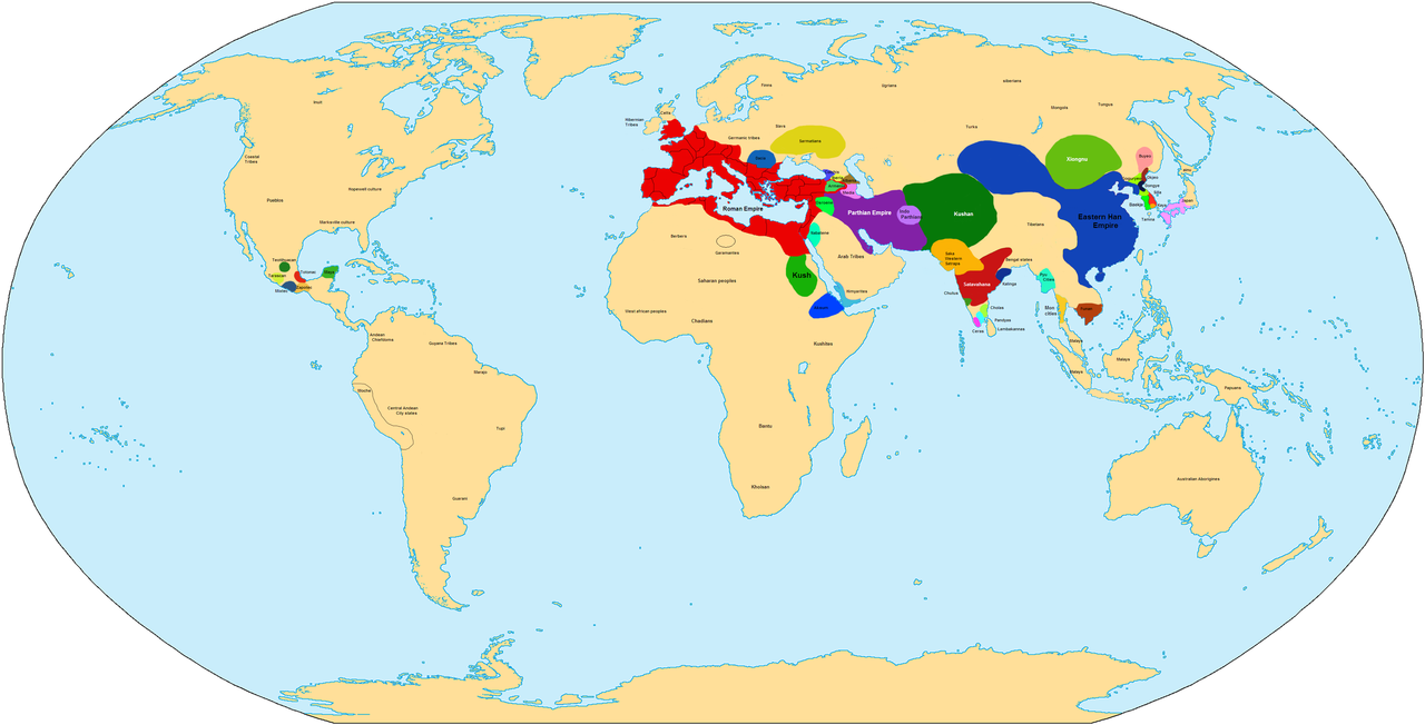
The World Map above shows the large empires that existed around 100 CE.